|
 ... Breakfast on the trail!
DAVE: Steve should get that one.
Nice morning! We collapsed the tent (on purpose this time) and got on the 64 east toward Cameron.
Along the way Dave screeched over to the other side of the road to take more pictures, because
that's what he does.

Photos - Click to Enlarge
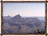
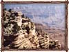
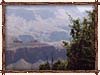
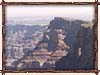
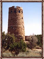 Along Highway 64 there is the Watchtower at Desert View, where we pulled off to finish off film
roll #5. It was built in 1932 as an observation station and rest stop, and designed to present
a better understanding of the Native American lifestyle. Rather than a restoration or copy, it's
a recreation of some of the odd prehistoric towers dotted about the Southwest, and created to
appear as a crumbling part of the canyon landscape. At the highest point on the South Rim --
7,522 feet above sea level and 70 feet above the ground -- it provides a magnificent view not only
of the Canyon as it winds away to the northeast, but a view of the beginnings of the desert. More
touristy-style information follows the usual quintet of popup pictures. ;)
Along Highway 64 there is the Watchtower at Desert View, where we pulled off to finish off film
roll #5. It was built in 1932 as an observation station and rest stop, and designed to present
a better understanding of the Native American lifestyle. Rather than a restoration or copy, it's
a recreation of some of the odd prehistoric towers dotted about the Southwest, and created to
appear as a crumbling part of the canyon landscape. At the highest point on the South Rim --
7,522 feet above sea level and 70 feet above the ground -- it provides a magnificent view not only
of the Canyon as it winds away to the northeast, but a view of the beginnings of the desert. More
touristy-style information follows the usual quintet of popup pictures. ;)
Photos - Click to Enlarge
While the towers upon which the Watchtower is based no longer exist as a part of the American Indian
way of life, they probably used to be for the storage of food and for protection in times of war.
Inside ladders would be drawn up to make it difficult for invaders to enter.
The tower contains a kiva, or sacred ceremonial chamber, around which the stairways of the
tower wind. Smoke from a fireplace underneath would purify descending and ascending participants
of meetings and ceremonies. All of the walls and ceilings are an illuminating record of Indian
art collected from various sources.
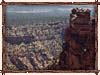
The top of this Watchtower was designed as an observatory, from which a pair of binoculars can
reveal objects many miles away, such as snow on the San Francisco peak to the south, a roving band
of mountain sheep in the canyons, or the Navajo school of Tuba City.
|
The bottom floor of the tower is, naturally enough, a large gift shop, from which we bought a
nifty little log-cabin-shaped incense burner and some very woody incense sticks. On to Cameron,
and Bianca takes the wheel. Singing a la Dylan/Hendrix: All along the watchtower...
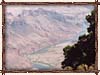
We did not stop along the road to Cameron, although upon entering the desert the landscape
changes dramatically. The earth and rock of the myriad canyons and buttes turn a murky copper, and
many ramshackle roadside trading posts begin to appear. These are hardly buildings; rather lean-tos
made of plywood, spare boards, anything the locals can get. There is a resolute sadness to these
roadside entrepreneurs, selling beef and buffalo jerky, rugs, but mostly jewelry. We are now in
16 million acres of Navajo land, passing signs detailing Indian mounds and "friendly Indians
ahead!" We continue on into the flatlands to Cameron, thoughtful, leaving the 64 behind to bend
north onto the 89.

Click to Enlarge |
The Trading Post at Cameron was, I believe, founded in 1916 or so, and started as a go-between
for the white traders and hunters and the Navajo. It grew into the huge gift shop/trading post,
hotel, gallery and restaurant it is today; we happened to hit it just as they were repaving the
parking lot, hence Bianca's nonplussed expression. We enjoyed some Navajo tacos, which are basically
taco salads atop Navajo fry bread, which is a sweet puffy bread. I couldn't help but pick up a book
about cowboy slang on the way out, just so I could know phrases like "he couldn't hit a bull's ass
with a banjo".
Once past Cameron the land flattens out into a weird geologist's wet dream. The land is different
on either side of the highway; on one side the red buttes and cracked earth of the Arizona desert;
on the other rolling, sandy desert scrub. Red and brown. Leaving the 89, We pass Tuba City, filling
up at a local Chevron, and trying not to think of the diner across the street advertising
"Velveeta burger heaven".
We now move on and up on the 160, to Kayenta and Monument Valley.
|
|


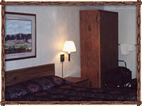 ... we stayed here. The hotel wasn't bad, not at all, and I will recommend the Best Western
Wetherill Inn to anyone who asks, but Gouldings is a lovely place.
... we stayed here. The hotel wasn't bad, not at all, and I will recommend the Best Western
Wetherill Inn to anyone who asks, but Gouldings is a lovely place.
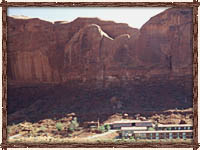
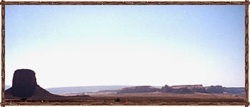
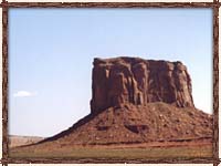 towering bastions of sandstone, siltstone and shale
rising like thrones from the near-treeless expanse of desert. Soon enough one pulls off the road
toward Gouldings, passing a new high school. Gouldings itself is tiny but well-designed and self-
sufficient, with its own little airport and an all-in-one gathering of hotel, restaurant, gift shop,
museum and tour nexus.
towering bastions of sandstone, siltstone and shale
rising like thrones from the near-treeless expanse of desert. Soon enough one pulls off the road
toward Gouldings, passing a new high school. Gouldings itself is tiny but well-designed and self-
sufficient, with its own little airport and an all-in-one gathering of hotel, restaurant, gift shop,
museum and tour nexus.